The following are some sample excerpts from the 5th edition of San Diego: An Introduction to the Region:
From pages 84–85:
The presence of gem quality tourmaline had been reported from the pegmatites in 1870, when Henry Hamilton discovered some outstanding prismatic crystals of pink and green color on Thomas Mountain in southern Riverside County. The Indians, too, had known of the tourmaline, and crystals have been found in many Indian graves. The first mining directed specifically at recovering these semiprecious gems seems to have been in 1898 at the Himalaya Mine in the Mesa Grande District (Figure 6.7). In addition to tourmaline, fine transparent quartz crystals, beryl ranging from blue aquamarine to peach colored morganite, spessartite garnet, pale rose kunzite, and topaz have been recovered.
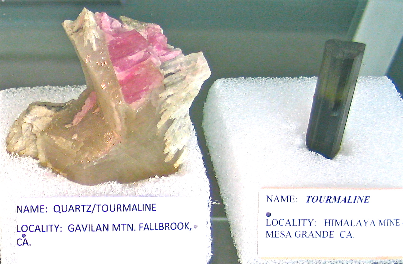
The gem market boomed through the early 1900s, and by 1910 fifty deposits were being worked in the Pala District alone. From 1907 to 1909 the Pala District produced over 730 pounds of gem tourmaline with an estimated value of $61,500. But events far from San Diego were to pop the gem bubble. Similar minerals were found in the Appalachians, much closer to the market and less expensive to mine. Then in 1912, the Chinese dynasty headed by the empress Tzu Hsi (who had an obsession with tourmaline) fell, and with it a main market for tourmaline. The mines lay idle for many years, or were worked by “week-end miners” every so often searching for new pockets of gems.
From pages 269–270:
Why is conserving biological diversity so important? This wealth of biological diversity (often shortened to simply “biodiversity”), is not just something to enjoy as we drive along our highways and byways, it is of immense practical importance to us as well, providing us with an abundance of valuable services at no cost. As previous chapters have noted, rivers provide our reservoirs with drinking water, floodplains collect our well water, plants stabilize our soils, birds and bats consume harmful insects, soils purify biological pollutants, and forests ameliorate our climate.
But at the invisible level, the genetic information contained in plants and animals may be the most important of all. To give just one telling example, the anti-cancer chemical taxol is derived from Pacific Northwest yew trees. Until recently, yew trees were routinely destroyed in the effort to log larger and more remunerative fir and cedar trees. Eventually, the great hidden benefit to people they contained was discovered. We don’t know what other plants might have similar secrets, but it only makes sense not to carelessly eliminate any elements of the natural environment, since any of them might harbor benefits not yet discovered. Biotic preservation is based on a combination of aesthetic, moral, and practical considerations.
As in other parts of the United States, serious efforts to conserve biodiversity did not commence in the San Diego region until after World War II. Prior to that time, the motivating force for landscape preservation had been mainly aesthetic (national parks) or even utilitarian (national forests). Eventually, the other benefits noted above slowly began to be recognized. This chapter will outline San Diego’s efforts to conserve its considerable natural wealth.
From pages 123–126:
Floods are a natural part of any river system, and this is certainly true for the rivers of San Diego County. Since accurate records began to be kept around the turn of the twentieth century, major floods have occurred in 1916 and 1927, and moderate sized floods in a number of other years, most recently 1998 (see Table 8.3). In dry years, however, the major streams of the county have on occasion had almost no runoff at all.
One unusual characteristic of the hydrology of San Diego County should be kept in mind concerning local flooding. Undammed streams in the southern California-western Arizona area have the greatest variability of runoff of anywhere in the United States. This reflects the fact that our rainfall is so highly variable. The main implication of this is that even greater caution should be exercised in building in the floodplains of San Diego County than elsewhere in the country, since the size and frequency of flooding on local streams is even more uncertain than elsewhere.
Nevertheless, today most of our major river valleys are at least partially developed. This has caused floodplain landowners to demand some form of flood protection, as well as engendering a counterargument that floodplains be left undeveloped as greenbelts. Either course of action is technically possible, depending on the desires of the local citizenry and their elected representatives. . . .
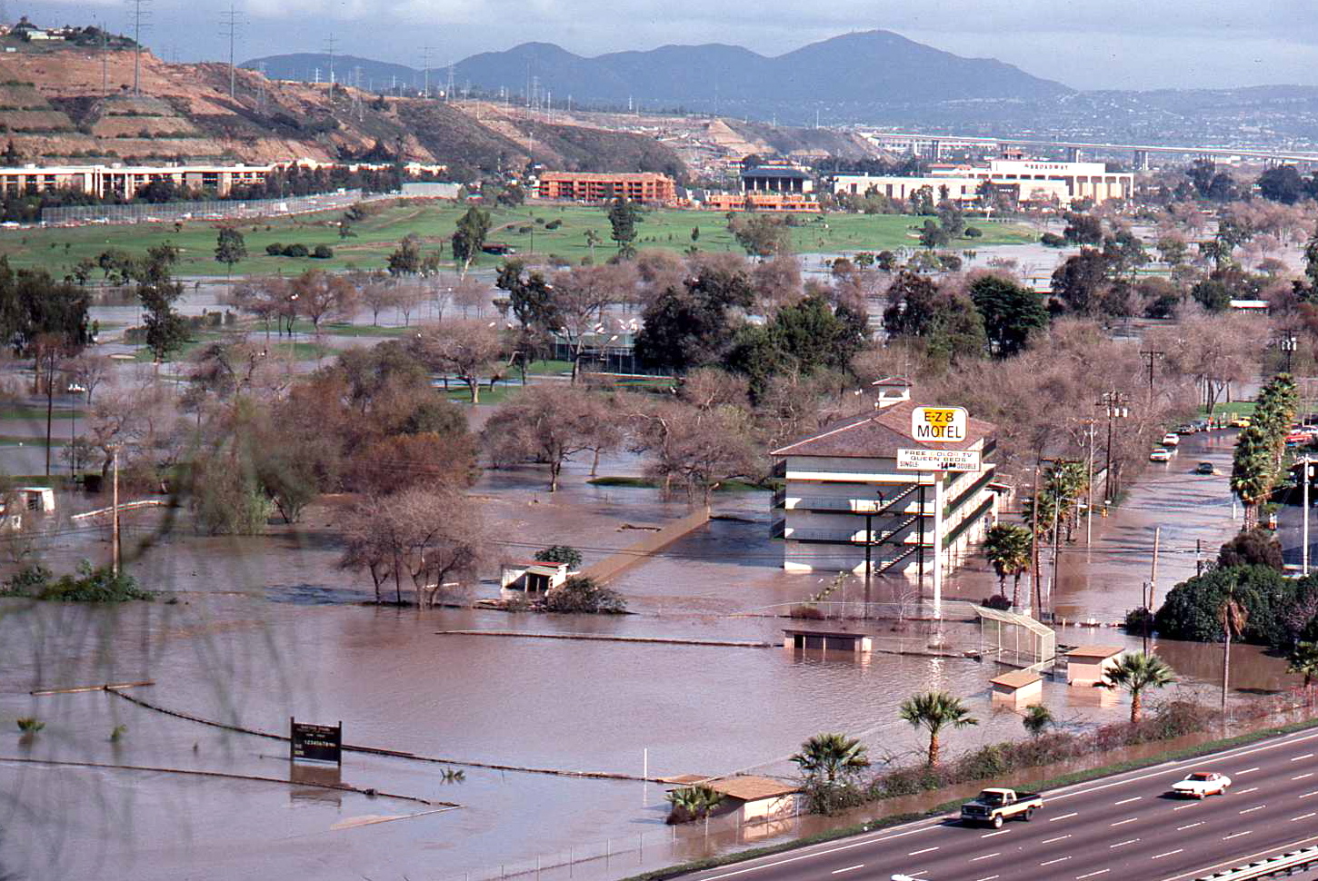
Mission Valley, along the lower San Diego River, is likewise a complex case because of the extensive development that has already been permitted in the floodplain. Serious flooding occurred in the valley in 1978, 1980, 1983 and 2010, and the lower valley was evacuated in February 1980 (Figures 8.12 and 8.13).
In 1976 the Corps of Engineers decided that federal funding for a channelization project in the Valley could not be economically justified, so the city and property owners between the SR 163 bridge and Qualcomm Way have cooperatively financed a natural-appearing (“soft-bottom”) channel in this area. It can safely convey a flood the size of the 1980 one, but not the size of the 1916 flood. It is also worth remembering that no formal flood protection presently exists between Interstate 5 and State Route 163.